
Is it Historic? Gracious? Sultry? Columbia, South Carolina encompasses each of these and much more! Columbia tantalizes all of your senses with a relaxing; comfortable pace; an abundance of playgrounds including Lake Murray, rivers, parks, gardens and the Riverbanks Zoo – one of the best in the country; the University of South Carolina and Fort Jackson. History abounds and is celebrated in museums, historic homes and even in repurposed buildings with a new start as shops and restaurants.
As the Palmetto State’s capital and a college town, Columbia’s fiery vibe cultivates a colorful arts scene while an indie spirit envelops several energized entertainment districts overflowing with locally owned boutique shops, eateries, spas and salons, and night spots. For those with an adventurous spirit, the rivers, trails or the Congaree National Park will provide endless fun. Food-lovers have over 450 restaurants to choose from and can pick a new feast for every day and night of the week. The variety is abundant and all with an easy reach. Once you’ve experienced Columbia, you’ll be delighted that you stopped to explore
|
Golf Course |
Specs | Phone |
Course Pro |
|---|---|---|---|
|
Coldstream C.C. |
18 71 |
781-0114 |
|
|
Coopers Creek G.C. |
18 72 |
894-4241 |
|
|
Crickentree |
18 72 |
754-8600 |
|
|
Golden Hills G.C. |
18 71 |
957-3355 |
Ron Garl |
|
Hidden Valley |
18 72 |
794-8087 |
Russell Breeden |
|
Indian River G.C. |
18 71 |
955-0080 |
Lyndell Young |
|
LinRick G.C. |
18 73 |
754-6331 |
Russell Breeden |
|
Mid-Carolina G.C. |
18 72 |
364-3193 |
Russell Breeden |
|
Northwoods G.C. |
18 72 |
786-9242 |
P. B. Dye |
|
Oak Hills G.C. |
18 72 |
735-9830 |
D. J. DeVictor |
|
Persimmon Hill |
18 72 |
275-2561 |
Russell Breeden |
|
Sedgewood G.C. |
18 72 |
776-2177 |
Russell Breeden |
|
Timberlake G.C. |
18 72 |
345-9909 |
Willard Byrd |
|
Windermere |
18 72 |
786-6088 |
Pete & P.B. Dye |
|
Woodlands C.C. |
18 72 |
786-6088 |
In Columbia, the weather is characterized by hot and muggy summers, cold winters, and a wet and partly cloudy atmosphere throughout the year. The temperature typically ranges from 36°F to 92°F, rarely going below 23°F or above 98°F.
The Real Estate Market in Columbia, South Carolina, presents a somewhat competitive landscape. Here’s an overview of the current market trends:
The real estate market in Columbia, SC is very strong right now, so it’s a great time to buy. Prices are expected to continue to rise as the city continues to grow. If you’re thinking about moving to Columbia, SC, now is a great time to do it. Contact Us.
Irmo is a town located in Lexington and Richland counties in South Carolina, United States. It is a suburb of Columbia and is part of the Columbia Metropolitan Statistical Area. The town was officially established in 1890 and is named after Captain C.J. Iredell and Henry Moseley.
As of July 1, 2022, the estimated population of Irmo is 11,942. The town’s demographics include:
Irmo’s housing statistics include:
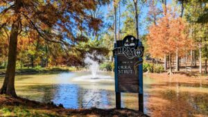
Irmo is known for its annual “Okra Strut” festival, started in 1973, featuring events like a charity golf tournament, street dance, live entertainment, arts and crafts exhibits, and a parade.
The town is governed by a town council of five members, including the mayor. As of February 2020, the mayor is Barry A. Walker Sr.
Irmo’s public schools include:
Notable individuals from Irmo include Tyler Bass, Ben Bridwell, Alaina Coates, Dustin Johnson, and Leeza Gibbons, among others, representing various fields such as sports, music, and television.
Irmo, South Carolina is a vibrant area located in the northwest region of Columbia, South Carolina. It offers a variety of neighborhoods for buyers looking for a place to call home. Irmo is primarily centered around the area encompassing Harbison Boulevard, Saint Andrews Road, Dutch Fork, and Lake Murray.
One of the key attractions of Irmo is its proximity to Lake Murray. Both Irmo and Lexington County, located on the other side of the dam, attract buyers who favor living close to this beautiful lake. The presence of Lake Murray provides residents with recreational activities such as boating, fishing, and lakeside living.
The neighborhoods in Irmo offer diverse housing options to cater to different preferences and budgets. Here are some of the notable neighborhoods in Irmo:
These are just a few examples of the neighborhoods in Irmo, South Carolina. Every neighborhood has its distinct charm and character that caters to various lifestyles and preferences.Whether you’re looking for a waterfront property, a family-friendly community, or a luxury estate, Irmo has something to offer for everyone.
Living in Irmo offers the convenience of easy access to major highways, including I-26 and I-126, making it a popular choice for commuters traveling to the Upstate (Greenville/Spartanburg) or those who want to enjoy the amenities of Columbia.
Overall, Irmo SC neighborhoods provide a range of housing options in a vibrant and convenient area, making it an attractive place to live for a diverse range of buyers.
The climate in Irmo, South Carolina, is hot and humid during summers and cold in winters, and it remains wet and partly cloudy throughout the year. The temperature typically ranges from 37°F to 92°F, with rare occurrences below 24°F or above 98°F.
Here are some key points about the weather in Irmo:
Cloud Cover: The percentage of the sky covered by clouds varies seasonally. The clearer part of the year is from around August 9 to November 26, with October being the clearest month. The cloudier period starts around November 26 and lasts for about 8.5 months, with January being the cloudiest month.
Precipitation: The wetter season lasts for about 3.1 months, from May 27 to August 29, with a greater than 33% chance of a wet day. July has the highest average number of wet days. Rain alone is the most common form of precipitation throughout the year, with the highest probability in July.
Solar Elevation: The solar elevation and azimuth vary throughout the year. The brighter period with higher solar energy lasts for 4.3 months, from April 10 to August 19, with June being the brightest month.
Humidity: Irmo experiences extreme seasonal variation in perceived humidity. The muggier period lasts for about 4.7 months, from May 16 to October 7, with July having the most muggy days.
Wind: The wind direction in Irmo varies throughout the day and from season to season. The prevailing wind directions are north, east, south, and west.
Best Time to Visit: The best times of year to visit Irmo for warm-weather activities are from late April to early June and from late August to mid-October. The third week of September typically has the highest score.
Growing Season: Irmo’s growing season typically lasts 8.0 months, from around March 16 to around November 15.
Source: Weatherspark

Lexington is the largest town in Lexington County, South Carolina, United States. Serving as the county seat, it is located in the northeastern part of the county and is considered a suburb of the state capital, Columbia.
The town has a rich history, with significant events such as the Battle of Muddy Springs and the Battle of Tarrar Springs taking place in the area during the Colonial Period and post-revolutionary era. During the American Civil War, Lexington suffered significant damage when Union forces destroyed much of the town, including the courthouse. However, the town gradually recovered economically with the help of local farms and the lumber industry. In the late 19th century, the Columbia to Augusta Railroad and the Lexington Textile Mill contributed to the town’s growth. Lexington continued to grow as a suburb of Columbia in the 20th century, particularly with the rise of automobile transportation and the creation of Lake Murray. The population of Lexington increased significantly between the 1990 and 2010 censuses, driven by its proximity to Columbia and the overall growth of the region. Notable events in recent history include the origin of the “move over law” that requires drivers to change lanes when there is a stopped emergency vehicle on the side of the road. Lexington was also struck by an F-3 tornado in 1994 and experienced historic flooding in 2015 due to remnants of Hurricane Joaquin.
Lexington has a mayor-council form of government, with the mayor and council members elected by the town residents.
The town is known for its recreational opportunities, including Lake Murray, and it has implemented measures such as a hospitality tax on prepared food items to fund road and traffic improvements.
Geographically, Lexington is situated in northeastern Lexington County and is approximately 12 miles west of Columbia. It has a total area of 12.12 square miles, with land accounting for 11.97 square miles and water covering 0.14 square miles. The town is drained by Fourteenmile Creek and Twelvemile Creek, both of which are tributaries of the Saluda River.
Lexington, South Carolina, is a vibrant town that offers a variety of neighborhoods, each with its unique charm and characteristics.
Belle Chase: This upscale neighborhood features homes ranging from the 400s to over a million dollars, catering to those seeking luxury living.
Berkshire: Known for its open floor plans, Berkshire offers modern living spaces that are both functional and stylish.
Caroline Springs: Positioned near shopping and entertainment centers, this neighborhood provides convenience and fun right at your doorstep.
Cherokee Village: This diverse community offers a variety of living options, accommodating different lifestyles and preferences.
Crosslake: With spacious lots and a variety of living options, Crosslake offers room to breathe and a sense of freedom.
Ashley Oaks: This neighborhood is characterized by its large, 2-acre average lot size, providing ample space for residents.
Bent Creek: Nestled amidst natural woods in Lexington, Bent Creek offers a serene and tranquil living environment.
Boardwalk Villas on Lake Murray: This waterfront community comes with a boat ramp, perfect for those who enjoy water activities.
Carriage Hill: Comprising Carriage Hill Place, Carriage Hill Lakes, and Carriage Hill Plantation, this neighborhood is surrounded by large, natural woods, offering a peaceful and scenic environment.
The Courtyards at River Club: Located off the scenic Corley Mill Road, this neighborhood offers beautiful views and a serene environment.
The list goes on, with neighborhoods like Cypress Woods, Baneberry, Bent Creek Plantation, Brandon Pass, Cherokee Shores, Creekwood, Farming Creek, Governors Grant, Hallmark Shores, Harbour Place, Keller’s Pond, Kleckley Colony, Laurel Falls, Mallory, Maritime Place, Millstream Crossing, Muirfield Place, The Palmettos, Parkside, Pilgrim Point, River Oaks, Settlers Point, Spence’s Point, Turner’s Pointe, Twelve Oaks Lane, Whiteford Lakes, and Wood Mill, each offering unique features and amenities.
From neighborhoods with easy access to downtown Columbia or Lexington, to those offering a variety of home styles on Lake Murray, or those with prices starting in the low 100s, there is a neighborhood for everyone in Lexington, SC. Whether you’re looking for a small community, a gated community, a neighborhood with a clubhouse, playground, and pool, or one with lakefront homes, Lexington, SC has it all.
Lexington, South Carolina, has a climate with hot and humid summers, cold winters, and it is generally wet and partly cloudy all year round. The temperature usually varies between 36°F and 91°F, with very few cases of temperatures below 23°F or above 98°F.
Here are some key details about the weather in Lexington:

West Columbia, South Carolina, is a city rich in history and modern appeal, located in Lexington County. Formerly known as Brookland, the city was incorporated in 1894 and later changed its name to West Columbia in 1936 to emphasize its proximity to the state capital, Columbia.
West Columbia is situated in the suburban eastern sections of Lexington County and is bordered to the east by Columbia, across the Congaree River. It’s near Columbia’s city center, the South Carolina State House, and the Congaree Vista. The city is also bordered to the south by its sister suburb, Cayce, and a small portion borders the town of Lexington to the east. The city’s total area is 6.3 square miles, with the Saluda and Congaree rivers to the south and west.
As of the 2020 census, West Columbia has a population of 17,416, with a diverse racial composition. The city has seen significant growth over the years, with a 16.2% increase in population from 2010 to 2020.
West Columbia’s history is marked by its original incorporation as “Brookland” and its subsequent name change. The city overlooks Columbia over the Congaree River and the Gervais Street Bridge. Several historic places, including the Gervais Street Bridge, Mount Hebron Temperance Hall, and Saluda Factory Historic District, are listed on the National Register of Historic Places.
West Columbia is part of the greater Columbia, SC metropolitan statistical area, making it a commuter town with easy access to the capital’s amenities. The city’s motto, “Bridging Past, Present, And Future,” reflects its blend of historical charm and modern conveniences. The median income for a household in the city is $30,999, and the area is home to various businesses, churches, and educational institutions, including Glenforest School.
West Columbia, South Carolina, is home to a diverse array of neighborhoods, each offering its unique charm and character. From the traditional elegance of Westover Acres to the urban convenience of Westwood Hills, these communities provide a rich tapestry of living experiences. Whether you’re drawn to the spacious lots and classic designs of Saluda Gardens or the family-friendly environment of Brookwood, West Columbia’s neighborhoods cater to a wide range of tastes and lifestyles. Explore the vibrant community life, excellent school districts, and convenient access to shopping, dining, and recreational facilities that make West Columbia a desirable place to call home.
Westover Acres is a charming non-gated neighborhood located in West Columbia, South Carolina. Developed in 1964, the community features traditional ranch-style brick homes with lot sizes averaging ½ acre or less and home sizes ranging from 2,000 to 4,000 square feet. With no HOA and average pricing, Westover Acres offers a welcoming environment for families. The neighborhood falls within the Lexington Two School District and is conveniently located near Sunset Blvd, Lexington Medical Center, and major interstate highways, providing easy access to shops, restaurants, and essential services.
Saluda Gardens is an established community in West Columbia, SC, known for its charming older homes and convenient updates. Homes in this subdivision range in price from $110,000 to $150,000, with square footages of 1,100 to 2,100, and three to four bedrooms. The community features large trees on spacious lots, chain-link fenced backyards, formal living and dining rooms, and some homes with hardwood floors. Located just minutes from downtown Columbia, the University of South Carolina, Riverbanks Zoo, Lexington Medical Center, and the Cayce/West Columbia River Walk, Saluda Gardens offers a perfect blend of suburban tranquility and urban accessibility. Students in the area attend the Lexington School District Two schools.
Brookwood is a residential neighborhood in West Columbia, offering a mix of traditional and contemporary homes. Known for its family-friendly environment, Brookwood provides a variety of housing options to suit different tastes and budgets. The community’s close proximity to schools, parks, shopping centers, and dining establishments makes it a convenient place to live.
Saluda Terrace is a picturesque neighborhood in West Columbia, characterized by its well-maintained homes and lush green landscapes. The community offers a range of housing styles, from classic ranch homes to modern designs. Saluda Terrace’s location near schools, recreational facilities, and shopping areas adds to its appeal for families and individuals seeking a peaceful yet connected living experience.
Westwood Hills is a vibrant community in West Columbia, known for its diverse architectural styles and welcoming atmosphere. The neighborhood features a mix of single-family homes, townhouses, and apartments, catering to various preferences and needs. Westwood Hills is strategically located near major roads and highways, providing easy access to educational institutions, healthcare facilities, shopping malls, and entertainment venues. The community’s blend of urban convenience and suburban comfort makes it a sought-after destination for homebuyers in the region.
In West Columbia, the weather exhibits distinct seasonal variations. The summers are hot and muggy, with temperatures ranging from 36°F to 92°F, while winters are cold. The best times for warm-weather activities are from mid-April to early June and from early September to late October.
Hot Season: Lasts for 3.7 months, from May 24 to September 15, with average daily high temperatures above 85°F. July is the hottest month with an average high of 91°F.
Cool Season: Lasts for 3.0 months, from November 28 to February 26, with average daily high temperatures below 63°F. January is the coldest month with an average low of 37°F.
Precipitation: West Columbia experiences rainfall throughout the year, with August being the wettest month and November the driest.
Humidity: The muggier period lasts for 4.7 months, from May 16 to October 7. July has the most muggy days.
Snowfall: The snowy period lasts for 4.2 weeks, from January 2 to February 1, with January having the most snow.
Sun: The length of the day varies significantly, with the shortest day on December 21 and the longest day on June 21.